
|
The Mayors team led by Douglas Oakervee, has announced outline details of the Estuary airport; The visualisation is conceptual and 'vague’ about actual locations.
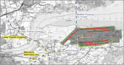
The plan has been transposed to scale in the image below.
|
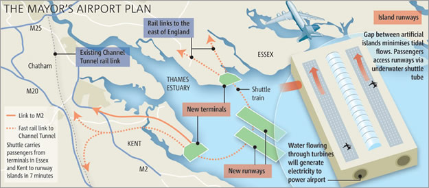
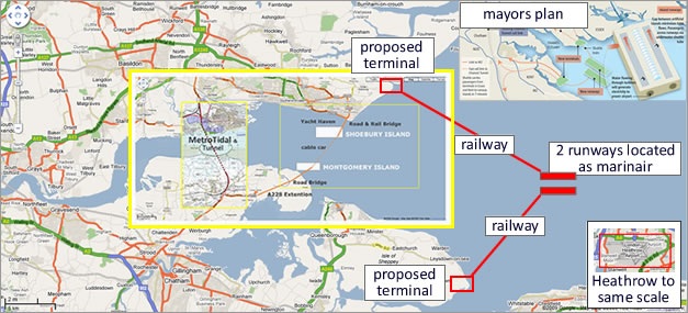
mayors airport plan The mayor’s scheme has two airport terminals; one each in Kent and Essex connected to a man made airport in the estuary by (approx) 30km of tunnel (10km to Kent & 20km to Essex) and shuttle trains under the estuary. By comparison, the Channel Tunnel is approximately 40km.
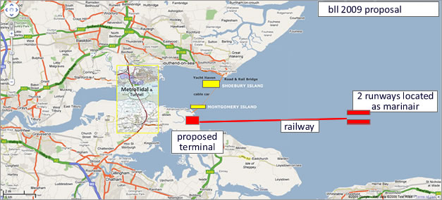
build LONDON Live plan The Bll plan would have a single terminal and tunnel connecting to the airport. The terminal would be on the Kent side of the Estuary at Grain so that the railway system could link to Eurostar. In this respect both schemes would be the same.
infrastructure advantage It would cost tens of billions of pounds to build an airport in the estuary, and so any proposal needs to provide more than an inward looking solution. The Bll master plan incorporates the Metrotidal proposals for a multi-modal (rail & road) tunnel under the Thames between Canvey Island and the Medway. This solution provides a massive boost to the regions infrastructure and would negate the requirement to have two tunnels in the estuary to the offshore airport; reducing the undersea tunnelling by at least 15km.
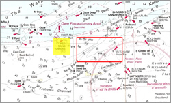
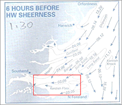
two islands - marinair The location of the airport in the mayor’s plan seems to be based on the TEACO Marinair proposals; details of which are limited (and have been criticised as such). From the available information this is to be located on the Kentish Flats where the water depth is less than 1 metre at low water springs. The latest proposals are for two runways on two islands connected by a tunnel beneath the sea; apparently to reduce any impact on tidal flows. It should be noted that the maximum spring tidal rates in this area (Kentish Flats) is 2.4 kts, 3 hours after HW Sheerness, but for most of the time it is a third of this. As such it is difficult to foresee any effective tidal power generation scheme as proposed by the mayor’s plan.
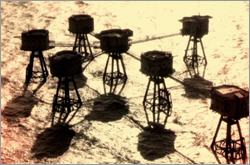
red sand forts The admiralty charts show the loaction to be just to the east of the Red Sand Forts.
runway orientation Some of the the most well developed proposals for an airport in the esturay are those for Cliffe Airport and Thames Reach Airport. Bll will use the runway orientation from them both; which in turn will define the shape of the island runways.
These pages contain a selection of contemporary airports
airport terminal location A viable alternative for the
location of the airport terminal is at Grain which is just 10km
from the proposed Metrotidal tunnel either across arable land
or along the shore. This location is also in close proximity
to existing road networks (A228) and only 20 minutes by car
to SE London. There is also enough land for car parking which
is one of the main issues to be dealt with.
bll competition A scheme for an airport, with a terminal & car park on Grain will be developed by Bll's architects. This in turn will be connected to an island in the estuary where the Bll competition will be held. |
|
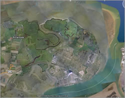
proposed airport @ Cliffe; note runway's
marinair Island (to scale) is next to forts
Red sand forts; shallow water, weak tides
relatively low tidal rates
Grain; the logical location of airport terminal |
bll 2009 proposals The Bll airport proposal with its single terminal on Grain and North to South road and rail infrastructure extension is more efficient than the latest proposals in the domain. It would be cheaper to build, easier to connect to existing road and rail networks and needs only one tunnel out to the airport. It will also integrate well with the Bll design competition.
|
||